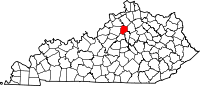
Frankfort, Kentucky
| Frankfort, Kentucky | |
|---|---|
| — City — | |
 |
|
 |
|
| Coordinates: | |
| Country | United States |
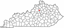
| State | Kentucky |
| County | Franklin |
| Established | 1786 |
| Incorporated | February 28, 1835 |
| Government | |
| - Type | Council/Manager |
| - Mayor | Gippy Graham |
| Area | |
| - Total | 15.0 sq mi (38.8 km2) |
| - Land | 14.7 sq mi (38.1 km2) |
| - Water | 0.3 sq mi (0.8 km2) |
| Elevation | 509 ft (155 m) |
| Population (2000) | |
| - Total | 27,741 |
| - Density | 1,883.2/sq mi (727.1/km2) |
| Time zone | Eastern (EST) (UTC-5) |
| - Summer (DST) | EDT (UTC-4) |
| ZIP Code | 40601-40604, 40618-40622 |
| Area code(s) | 502 |
| FIPS code | 21-28900 |
| GNIS feature ID | 0517517 |
| Website | City website |
Frankfort is a city in the Commonwealth of Kentucky that serves as the state capital and the county seat of Franklin County.[1] The population was 27,741 at the 2000 census; by population, it is the 5th smallest state capital in the United States. Frankfort is the principal city of the Frankfort, Kentucky Micropolitan Statistical Area, which includes all of Franklin and Anderson counties.
Contents |
History
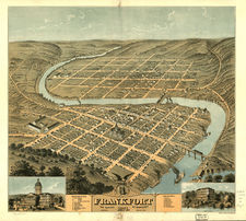
The town of Frankfort probably received its name from an event that took place in 1780s when Indians attacked a group of pioneers from Bryan’s Station who were making salt at a ford in the Kentucky River. One of the pioneers, Stephen Frank, was killed and the crossing became known as "Frank’s Ford." Later this name was shortened to Frankfort.
In 1786 James Wilkinson purchased the 260-acre (1.1 km2) tract of land on the north side of the Kentucky River that is now downtown Frankfort. He was an early promoter to make Frankfort the country's capital.
After Kentucky became a state, five commissioners were appointed on June 20, 1792, to choose a location for the state capital. They were John Allen and John Edwards (both from Bourbon County), Henry Lee (Mason County), Thomas Kennedy (Madison County), and Robert Todd (Fayette County). A number of communities competed for this honor, but Frankfort won by perseverance and, according to early histories, the offer of Andrew Holmes' log house as capitol for seven years, a number of town lots, £50 worth of locks and hinges, 10 boxes of glass, 1,500 pounds of nails, and $3,000 in gold.[2]
Frankfort had a post office by 1794, with Daniel Weisiger as postmaster.[3]
John Brown, a Virginia lawyer and statesman, built a home, now called Liberty Hall, in Frankfort in 1796. Before statehood he represented Virginia in the Continental Congress (1777–78) and the U.S. Congress (1789–91). While in Congress he introduced the bill granting statehood to Kentucky. Once that was accomplished, he was elected a U.S. Senator for Kentucky.
The Kentucky General Assembly appropriated funds to provide a house to accommodate the governor in 1796. Construction was completed in 1798. The Old Governor's Mansion is reputed to be the oldest official executive residence still in use in the United States.
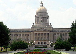
In 1829 the Old Capitol, the third Capitol of Kentucky, was built in the Greek Revival style by Gideon Shryock. The building served Kentucky as its Capitol from 1830 until 1910.
During the American Civil War fortifications overlooking downtown Frankfort were built on what is now called Fort Hill. The Confederate Army occupied Frankfort for a short time.
On February 3, 1900 Governor-elect William Goebel was assassinated in Frankfort while walking to the capitol to be inaugurated. Former Secretary of State Caleb Powers was later found guilty in a conspiracy to kill Goebel.
The city has seen considerable growth since the 1960s. A modern addition to the State Office Building was completed in 1967. The original building was completed in the 1930s on the location of the former Kentucky State Penitentiary. Some of the stone from the old prison was used for the walls surrounding the office building. Capitol Plaza was established in the 1960s. The Plaza consists of the Capitol Plaza Office Tower, the Capitol Plaza Hotel (formerly the Holiday Inn, Frankfort), and the Fountain Place Shoppes. The Capital Plaza Office Tower opened in approximately 1968. In August 2008, officials revealed a plan to demolish the Capitol Plaza Office Tower and redevelop the area over a period of years, replacing the Tower with a smaller, four- or five-story building.[1]
Frankfort is home to several major distilleries of Kentucky Bourbon whiskey, including Buffalo Trace Distillery (formerly Ancient Age).
Historic churches
- Church of the Ascension Episcopal Church was organized in 1835. It is located at 311 Washington Street in Frankfort’s historic district and is on the National Register of Historic Places.
- Good Shepherd Roman Catholic Church was built in 1850. It is located at 310 Wapping Street in Frankfort’s historic district and is on the National Register of Historic Places.
Geography
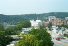
Frankfort is located at (38.197274, -84.863110)[4]. It is in the (inner) Bluegrass region of Central Kentucky.
The city is bisected by the Kentucky River, which makes an s-turn as it passes through the center of town. The river valley widens at this point, which creates four distinct parts of town. The valley within the city limits contains "downtown" and "south" Frankfort districts, which lie opposite one another on the river. A small neighborhood with its own distinct identity, Bellepoint, is located on the west bank of the river to the north of Benson Creek, opposite the river from the "downtown" district. The suburban areas on either side of the valley are referred to as "west" Frankfort and "east" Frankfort, respectively.
According to the United States Census Bureau, the city has a total area of 15.0 square miles (39 km2), of which 14.7 square miles (38 km2) is land and 0.3 square miles (0.78 km2) is water.
Frankfort does not have a commercial airport and travelers generally fly into Bluegrass Airport in Lexington or Louisville International Airport.
Climate
Frankfort is located at the northern extreme limit of the humid subtropical climate of the Southeastern United States. It is proximal to the climatic transition zone where the subtropical Southeast blends with and then eventually changes to a humid continental climate further north (roughly just beyond Cincinnati, Ohio and Indianapolis, Indiana).
| Climate data for Frankfort, Kentucky | |||||||||||||
|---|---|---|---|---|---|---|---|---|---|---|---|---|---|
| Month | Jan | Feb | Mar | Apr | May | Jun | Jul | Aug | Sep | Oct | Nov | Dec | Year |
| Source: The Weather Channel.[5] | |||||||||||||
Demographics
| Historical populations | |||
|---|---|---|---|
| Census | Pop. | %± | |
| 1800 | 628 |
|
|
| 1810 | 1,099 | 75.0% | |
| 1820 | 1,679 | 52.8% | |
| 1830 | 1,682 | 0.2% | |
| 1840 | 1,917 | 14.0% | |
| 1850 | 3,308 | 72.6% | |
| 1860 | 3,702 | 11.9% | |
| 1870 | 5,396 | 45.8% | |
| 1880 | 6,958 | 28.9% | |
| 1890 | 7,892 | 13.4% | |
| 1900 | 9,487 | 20.2% | |
| 1910 | 10,465 | 10.3% | |
| 1920 | 9,805 | −6.3% | |
| 1930 | 11,626 | 18.6% | |
| 1940 | 11,492 | −1.2% | |
| 1950 | 11,916 | 3.7% | |
| 1960 | 18,365 | 54.1% | |
| 1970 | 21,902 | 19.3% | |
| 1980 | 25,973 | 18.6% | |
| 1990 | 25,968 | 0% | |
| 2000 | 27,741 | 6.8% | |
| Est. 2009 | 27,382 | [6] | −1.3% |
| U.S. Census Bureau[7] | |||
As of the census[8] of 2000, there were 27,741 people, 12,314 households, and 6,945 families residing in the city. The population density was 1,883.2 per square mile (727.1 /km2). There were 13,422 housing units at an average density of 911.2 per square mile (351.8 /km2). The racial makeup of the city was 81.84% White, 14.70% Black or African American, 0.13% Native American, 0.94% Asian, 0.03% Pacific Islander, 0.77% from other races, and 1.60% from two or more races. Hispanics or Latinos of any race were 1.48% of the population.
There were 12,314 households out of which 26.4% had children under the age of 18 living with them, 38.9% were married couples living together, 14.1% had a female householder with no husband present, and 43.6% were non-families. 37.6% of all households were made up of individuals and 13.1% had someone living alone who was 65 years of age or older. The average household size was 2.14 and the average family size was 2.83.
The age distribution was 21.6% under 18, 11.7% from 18 to 24, 30.3% from 25 to 44, 22.4% from 45 to 64, and 14.0% who were 65 or older. The median age was 36 years. For every 100 females there were 91.1 males. For every 100 females age 18 and over, there were 86.2 males.
The median income for a household in the city was $34,980, and the median income for a family was $47,855. Males had a median income of $31,339 versus $25,361 for females. The per capita income for the city was $20,512. About 9.5% of families and 13.9% of the population were below the poverty line, including 19.3% of those under age 18 and 14.8% of those age 65 or over.
Frankfort is the focal point of a micropolitan statistical area consisting of Frankfort and Franklin County as well as adjacent Lawrenceburg and Anderson County. The city is also classified in a combined statistical area with Lexington and Richmond to the east.
Education
Frankfort is the home of the Kentucky State University, a historically black university situated near the downtown area. Two school districts serve the city, with three public high schools within the city limits:
- Frankfort Independent Schools, whose boundaries roughly coincide with downtown, South Frankfort, and the Bellepoint and Tanglewood neighborhoods:
- Frankfort High School
- Franklin County Public Schools, covering the rest of the county:
- Franklin County High School, primarily serving the eastern half of Franklin County
- Western Hills High School, serving west Frankfort and western Franklin County
Private high school:
Frankfort, Franklin County and the surrounding area also have a considerable homeschooling population Motivating Independence Nurturing Development
Sister cities
Frankfort has one sister city:
 San Pedro de Macorís, Dominican Republic.
Notable residents
- William Wirt Adams (1819–88), born in Frankfort, brigadier general in the Confederate Army[9]
- Elijah Craig, preacher and bourbon distiller
- Elizabeth Ann Hulette (November 19, 1960 – May 1, 2003) professional wrestling manager and valet. Attended Franklin County High School
- John Marshall Harlan, former Franklin County judge. Later served on the U.S. Supreme Court and is notable for being the lone dissenter in Plessy v. Ferguson and the Civil Rights Cases, which struck down anti-discrimination laws as unconstitutional.
- Paul Sawyier (1865–1917) was a Kentucky artist and an American Impressionist
- George Graham Vest (1830–1904) U.S. Senator from Missouri, orator
- George C. Wolfe (September 23, 1954 - ), Broadway producer/playwright and film director.
- Will Chase is an actor and singer, best known for his work in Broadway musicals.
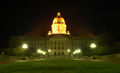 Kentucky's Capitol building at night |
Kentucky Governor's Mansion |
 A floral clock near the Capitol building |
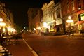 Downtown Frankfort at night |
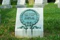
 Grave site of pioneer Daniel Boone and his wife at Frankfort Cemetery |
 Grave site of impressionist painter Paul Sawyier at Frankfort Cemetery |
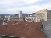
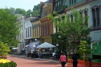 Downtown Frankfort |
 Buffalo Trace Distillery |
References
- ↑ "Find a County". National Association of Counties. http://www.naco.org/Template.cfm?Section=Find_a_County&Template=/cffiles/counties/usamap.cfm. Retrieved 2008-01-31.
- ↑ Kentucky Historical Society website, Kentucky Historical Marker number 1774
- ↑ Rennick, Robert M. (1993) Kentucky's Bluegrass: A Survey of the Post Offices, p. 91, p. 99. Lake Grove, Oregon: The Depot, ISBN 0-943645-31-X (PO Department records were destroyed by a fire in 1836; October 1, 1794 is the date of the first quarterly account sent to Washington by Mr. Weisiger)
- ↑ "US Gazetteer files: 2000 and 1990". United States Census Bureau. 2005-05-03. http://www.census.gov/geo/www/gazetteer/gazette.html. Retrieved 2008-01-31.
- ↑ "MONTHLY AVERAGES for Frankfort, KY". The Weather Channel. http://www.weather.com/weather/wxclimatology/monthly/USKY0919. Retrieved July 29, 2010.
- ↑ Annual Estimates of Resident Population for Incorporated Cities in Kentucky: April 1, 2000 to July 1, 2009 United States Census Bureau. Retrieved on 2010-07-29
- ↑ Historical Census Data Retrieved on 2010-02-29
- ↑ "American FactFinder". United States Census Bureau. http://factfinder.census.gov. Retrieved 2008-01-31.
- ↑ Who Was Who in America, Historical Volume, 1607-1896. Chicago: Marquis Who's Who. 1963.
External links
- Official site
- Kentucky Coffeetree Cafe
- Links2Frankfort Local Business Directory
- Frankfort Information page from Kentucky Secretary of State
|
|||||||||||||
|
||||||||||||||
|
||||||||||||||||||||
|
|||||
|
||||||||